A visit to SE Australia: images and observations

My wife, dog, drone and I took our Honda Jazz and camper trailer from our home in Mid-north South Australia to the east coast for a three-week holiday in late Spring. We left home on 2016/10/30 and returned on 2016/11/20.

This page is not meant to be a record of the holiday, I have aimed at showing photos that will be of some interest to others.

 
It happened that the few months before our holiday was unusually wet in the Murray-Darling Basin. Consequently we were lucky to see most of the water storages full or very close to it, and good flows in the rivers.

Most of the images on this page have high definition versions that can be viewed by clicking on the photos (or touching them if you are using a tablet).

I started on this page on 2016/11/21, it was last edited 2021/04/02
Contact: David K. Clarke – ©

Travelling eastward

Murray Basin

 
Flood waters

Euston/Robinvale

Our first night was at Euston in New South Wales, just across the Murray from Robinvale (Victoria). The river level was high and rising; this photo was taken from beneath the bridge that connects the two towns.

Socrates was having a good look around, examining all the local smells, as is his wont.

By the way, we stayed at the Euston Riverfront Caravan Park and looking back on it, that was one of the best-equiped camping grounds of the whole trip, and the fee was low.

Click on (or touch) the image to see it in more detail.

2016/11/01

 
Flood waters
A view from the Euston-Robinvale bridge

2016/11/01


Euston bridge
 
The Euston-Robinvale bridge showing the widespread floodwaters covering the flood-plain. Robinvale is on the left, Euston in the distance in the upper-centre.

The image is a stitch of six drone photos covering well over 180 degrees; the bridge is actually straight.

2016/11/01


Irrigation channels

Irrigation channels near Hay

About 40km west of Hay, on the great plain of the Murrumbidgee, in an area too dry to grow cereal crops, we came across these unlined irrigation channels. We saw no irrigated areas from the ground; it was only after looking at some photos taken from my drone at perhaps 100m altitude that I saw some irrigated paddocks in the distance (one is just visible on the far right of the image).

The losses due to evaporation and soakage from these very long channels must be enormous; the losses due to flood-irrigation, if that method is used, at the ends of the channels would probably be even greater. On a later trip I recorded a more water-efficient irrigation system than flood irrigation that is used in at least some of this area.

In late 2016 the (Liberal-National Coalition) Federal government is intending to increase the amount of water that can legally be taken from the Murray-Darling river system and reduce the amount reserved for the environment.

Perhaps if the huge waste in the current irrigation practices, such as to be seen here, was cut out, we would have enough water for both irrigators and environment?

Click on (or touch) the image to see it in more detail.

2016/11/01


Irrigation channel
The same irrigation channel, from the ground.

This, compared to the previous photo taken from my drone, shows the value of a drone in providing an idea of a large feature on flat ground.

2016/11/01

 
Street garden

Narrandera

This pretty little street garden was in the main shopping street of Naranderra.

My wife and I thought that if the town had such nice little gardens, even in the main street, there would be bound to be more extensive gardens elsewhere in town that would be well worth a visit. Unfortunately, as we were informed in the tourist information centre, not so.

2016/11/02

 
Old brewery

An interesting development in Narrandera

On the bank of the Murrumbidgee in Narrandera this was an interesting looking development. The tall building is the remains of an old brewery; there was no indication of what was being built.

2016/11/02

 
Gundagai

Gundagai

There is a lookout at South Gundagai that is well worth driving up to. We had visited Gundagai several times, but didn't know about the lookout until we happened to see a sign to it while looking for the Tumut road.

Both these photos are from the lookout.

Click on (or touch) the image to see it in more detail.

2016/11/02


Gundagai


Snowy area

Tumut

 
Tumut River
The drone is looking roughly north, away from the township of Tumut. Tumut Wetlands is in the foreground.

2016/11/03


Tumut
The image is a stitch of three drone photos. Tumut Wetlands is in the foreground, the town in the background. On the right is the water treatment works; note the solar power installation.

2016/11/03


Early morning

Early morning mist

Tumut was the first place we stayed more than a single night.

The photo on the right was taken using a drone early one morning while there was a low mist.

2016/11/04


Tumut River

Tumut River

This photo was taken on another misty morning from near the door of our camper in the Riverglade Caravan Park (one of the best in which we stayed on this holiday for its location, beauty and facilities).

2016/11/03

 
Tumut view
On an early morning walk across the Tumut River from the Riverglade Caravan Park, Tumut.

2016/11/03

 
Horses
There are a lot of horses in paddocks on the outskirts of Tumut. These were seen on the same early morning walk as the previous photo.

2016/11/03


Tumut Valley
The valley of Tumut as seen from my drone in the early morning.

This world is beautiful beyond imagining. How can our stupid politicians think that a quick buck is more important than looking after it?

2016/11/04


Tumut morning
Early morning at Tumut

This composite of five wide-angle drone images probably covers around 180 degrees.

2016/11/04

Adelong gold mill ruins

Adelong is a town a short drive from Tumut.

 
Adelong gold processing area
We went looking for Adelong Falls and found something more interesting – these ruins of the Adelong gold processing installation.

We were not sure whether the Adelong Falls was the cascades through the gold processing area or whether they were somewhere else. We did look for them elsewhere, but didn't find them.

2016/11/03


Buddle
On the right is the remains of the lower (main) water wheel. A sign at the water wheel read:
"Built in 1870, the [7.9m] 26-foot overshot reverse wheel drove all the machinery through the life of the mill. The water stored in a log weire in front of the lower race headwall was delivered via the lower race through the sluice gate in the head wall.

Operating around 3.5 rpm it developed [26 kW] 35 horse power per minute (SIC), the wheel was 1.4m wide and required 31.2KL of water per minute to fill its 64 buckets."
There was also an upper water wheel that developed 19 kW.

On the left the large round thing is the buddle.

2016/11/03

 
There is more about these ruins in the Adelong falls and gold mill ruins site.

Dams near Tumut

Blowering, Jounama and Talbingo dams are easily visited in a day trip from Tumut. The first and last of the three are amoung the largest dams in Australia.

 
Blowering

Blowering Dam

At 1,628GL capacity this is one of the biggest storages in the Snowy Mountains region.

The concrete 'parepet wall' on top of the dam wall was completed in 2010. It was built to increase the safety of the dam in extreme flood events. Extreme flood events are, of course, more likely due to the climate change threat that (Liberal in particular) Australian governments seem determined to ignore.

2016/11/04


Blowering Dam
Blowering Dam, a stitch of five wide angle drone photos covering nearly 180 degrees. The spillway, on the right, is actually on the right abutment of the dam wall.

2016/11/04


Blowering
A drone image of Blowering Dam. Our car is the little blue one near the gate.

2016/11/04


Talbingo Dam and power station

 
Talbingo

Talbingo power station

A drone photo taken from around 120m above the ground level in the parking area south of the power station. The intake weir at the end of the head-race and the top of the pressure pipes is not visible from ground level.

The Power Station, called Tumut 3, was upgraded in 2012 from 1500MW to 1650MW. It is one of the few hydro-power stations in Australia to include pumped hydro in which water is pumped from the lower Jounama Pondage to the upper Talbingo Reservoir when electricity is plentiful and cheap, so that it can flow back down through the turbines to generate more electricity at times of higher demand.

The development of more electricity storage such as pumped hydro is very important if the world is to move from fossil fuels to renewable energy such as solar and wind power.

Visitors used to be able to go into a viewing area in the Talbingo Power Station. I don't know of any other hydro power station in Australia that has a viewing area. It was closed on this visit; I wonder if it is always closed now?

2016/11/04


Turbines
It seems that those in charge of the Snowy Mountains power stations and dams place some remote chance of an accident liability claim ahead of people enjoying themselves.

The fences around these turbines stop kids climbing on or through them. Kids would have fun doing that. There would be very little risk of injury, no more than if the kids were to climb on the hillside behind the turbines.

The banning of any water activities on Jounama pondage is a similar denial of fun for the sake of some tiny, even imaginary, risk.

2016/11/04

 
Talbingo head-race

Talbingo power station head race

The head-race from the reservoir side; taken using my drone. The weir at the end of the head-race is not visible from any of the ground level viewing points.

The road is the one that leads to the dam.

2016/11/04


Talbingo head-race

Talbingo dam and head-race for the power station

Looking from a point over the head-race southward up the Tumut valley; Talbingo Dam is on the left.

2016/11/04

 
Talbingo

Talbingo Dam

From the dam wall looking upstream, south. On the right is the intake structure for the release of water downstream.

2016/11/04

 
Talbingo
Talbingo Dam again, the spillway is in the cutting on the far left, the power station intake channel passes through the cutting on the right. From the dam wall looking upstream, south.

2016/11/04


'Dangerous' Jounama

 
Sign
 
Jounama from Talbingo township
Sign
My wife and I had lunch at the general store in Talbingo township on the shore of Jounama Pondage.

We noticed the sign on the right and thought it foolish. Reading a submission from Clayton Barnes to the NSW Department of Primary Industry, dated 2013/10/10, confirmed that first impression. Mr Barnes states that the water level "rises and falls at a rate no greater than the tides on the coast". How this can be considered dangerous, while the big lakes behind the Blowering and Talbingo dams and fast flowing rivers like the Tumut is considered safe has to be beyond the comprehension of any reasonable person.

Mr Barns states that the lake was closed to the public at a time when it was contaminated with sewage; that problem was solved long ago. He makes the very reasonable point that opening Jounama Pondage for non-powerboat recreation would bring many tourists and business to Talbingo township.

A little of Jounama Pondage as seen from Talbingo township can be seen in the lower image on the right.

2016/11/04


Tumut to Canberra

 
Church

Timely church

This little church is on the road from Tumut to Wee Jasper. There is no town nearby, you'd wonder why anyone would build even such a small church in a place like this.

When I first came across it just over two years before this photo was taken I was with a small group on a walk for climate change from Melbourne to Canberra. On that particular day, 2014/10/14, the weather was cold, the temperature did not rise above nine degrees and there was light rain the whole day. It was time for us to stop for lunch when we came across this church and we took full advantage of the little porch to get out of the rain. It was far more pleasant than standing around in the cold rain preparing sandwiches and eating them.

Click on (or touch) the image to see it in more detail.

2016/11/04


Echidna

Echidna

We happened to come across two echidnas on this holiday; in an average year we wouldn't see one.

For those not in the know, echidnas are monotremes, egg-laying mammals.

This little bloke seemed not much concerned about us. If he noticed us move he would hide his head for a few minutes, but then he'd go back to foraging.

The other echidna we came across was in the Jervis Bay area.

2016/11/05

 
Duck 'n Fishes

Duck 'n Fishes restaurant, Wee Jasper

Wee Jasper is, by eastern NSW standards, a very small, very remote town. We were hoping to buy something for lunch. I remembered from two years previously that there had been a small shop that sold fast food and drinks; it was closed. There was another place across the road that, judging from the signs, was open sometimes, but not when we were there.

However, there were signs pointing to a restaurant called the Duck 'n Fishes on a road other than the one we came in on or were going out on. This seemed a very unlikely place for a restaurant, but we thought we might as well give it a try, after all, we were sight-seeing.

Anyway, it was there, in a beautiful location by Lake Burrinjuck, it was open for business, and it provided us with good meals.

2016/11/05

 
Duck 'n Fishes

Duck 'n Fishes

From my drone, Lake Burrinjuck and the valley of the Murrumbidgee River in the background.

2016/11/05


Duck 'n Fishes road

The road into Duck 'n Fishes

It was about six kilometres from Wee Jasper to the restaurant, but the views along the way make it a pleasant drive.

2016/11/05

 
Duck 'n Fishes road
Looking north along the Murrumbidgee valley and Lake Burrinjuck from the road that climbs out of Wee Jasper toward Yass and Canberra. Duck 'n Fishes may be just visible to the right of the big hill in the centre of the image (in the full-definition version of the image).

2016/11/05


Canberra region

Mount Stromlo

 
Mount Stromlo
Mount Stromlo, on the outskirts of Canberra, is well worth a visit; for the views and a visit to the cafe even if you are not interested in astronomy, but there are some excellent and informative science displays; I was particularly impressed with the one that showed how spectral analysis of star light is done.

It happened to be very windy when we were on Mount Stromlo. Had it been calmer it would have been a great place to get some drone photos.

2016/11/05


Beijing Garden

Beijing Garden

Canberra has very good Chinese and Japanese gardens by Lake Burley Griffin.

2016/11/06


Beijing Garden
Beijing Garden again

2016/11/06

 
Beijing Garden
Beijing Garden again. The big stone on the left is a 'stone of appreciation from Tai Lake'.

2016/11/06

 
Japanese Garden

Japanese garden, Nara Peace Park

This is immedeately adjacent to the Beijing Garden

2016/11/06


Japanese Garden
Nara Peace Park again

2016/11/06

 
Cotter Dam

Cotter Dam

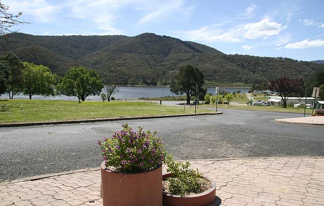
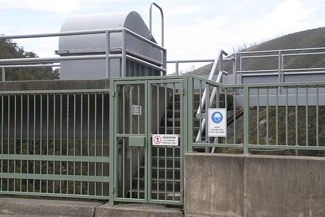
We were lucky to visit the Cotter Dam when it was overflowing. My friend Bill Gresham tells me that if overflowed for the first time in October.

This is the largest storage in the Australian Capital Territory. However, Googong reseroir, just over the NSW border near Queanbeyan, is the biggest in the Canberra water supply system. Bill tells me that the four dams for the two cities are all managed as one system. More information from Icon Water.

This photo was taken with my Phanton 3 Advanced drone.

2016/11/07

 
Tidbinbilla

Tidbinbilla Deep Space Tracking Station

This station is involved with communication with space probes, not astronomy as at Mount Stromlo. There are many interesting and informative displays.

In the forground is the Honda Jazz that took us (and towed our camper trailer), without any problems, more than 3000 kilometres including twice over the Snowy Mountains. While towing the trailer it averaged from 6.5 to 7 litres per hundred kilometres; producing less than half as much greenhouse gas as many or most of the large four-wheel-drive/caravan combinations that are more common.

2016/11/07

Solar power installations

 
Williamsdale

Williamsdale solar farm

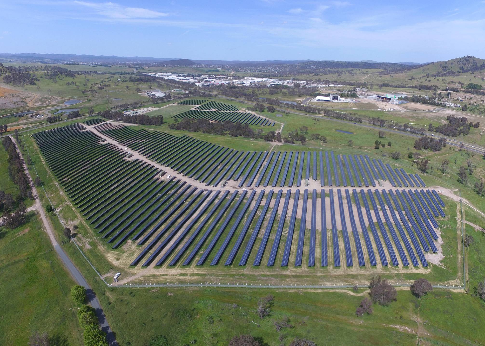
Early construction stage. There will be 35,000 panels, rated at a total of 11MW, covering 29ha of ground.

This solar farm was originally to be built across a road from Uriarra, but the people of the town did not want it 'spoiling their view'.

The delay of a couple of years caused by the arguments and delay has probably been very good for the builders. I believe that they will be paid the original contracted price while the cost of solar panels has fallen greatly.

The biggest of the ACT's solar farms is Royolla, rated at 20MW.

2016/11/07


Mugga Lane

Mugga Lane solar farm

The Australian Capital Territory (ACT) government has an target of 100% renewable electricity by 2020. It seems that there are no suitable sites for wind farms in the ACT, but they are building solar farms. They have contracted to buy wind power from South Australia and Victoria.

Mugga Lane is rated at 13MWac.

2016/11/07

 
Mount Majura

Mount Majura solar farm

This is rated at a relatively small 2.3MW.

A community-owned solar power station is to be built adjacent.

 
Shadow
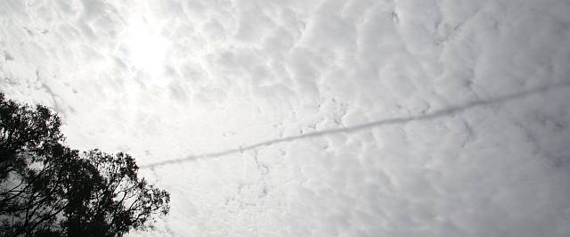
An unusual sight, the shadow of a vapour trail on thin clouds. The photo was taken from the Mount Majura solar farm.

2016/11/08


To the east coast

 
Waterfall

Tianjara Falls

This waterfall was close to the road between the little town of Nerriga, where we had lunch, and the coast. As can be seen, the flow was small; but the view was good.

The geomorphology seemed very similar to that around Sydney, with flat-lying sandstone beds with deep valleys coming to sudden ends at high cliffs.

2016/11/08

 
Forest
Some of the beautiful forest of Booderee National Park in the Jervis Bay area.

The Honda Jazz and camper trailer that we used consumed an average of 6.5 to 7 litres of petrol per 100km.

2016/11/09

 
Stag-horns
Stag-horns growing in the botanic gardens in Booderee National Park.

These gardens are well worth a visit.

2016/11/09

 
Beach
The green of the algae gives the beach at Moruya Heads more colour than many beaches.

2016/11/10

 
Beach
An interesting rock formation on the beach at Moruya Heads.

2016/11/10

 
Forest

Cycads in the forest SW of Moruya

These are members of a very ancient group of plants – the earliest of the seed-bearing plants.

Most of the trees are Eucalypts, species unknown to me, but they did include quite a few spotted gums.

2016/11/10


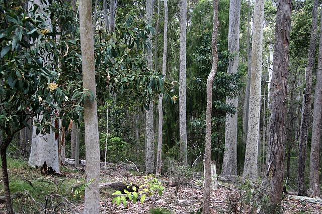
Spotted gum, Corymbia maculata, forest
Forest

Spotted gums

I have long loved spotted gums (Corymbia maculata); I've planted a number of them at Elysium.

Denece and I took pot luck and drove through some forest roads inland from Bermagui and came across this forest of spotted gums. It seems that a strip just inland from the coast in this area is the main natural occurrence of the species.

I wonder why they are called 'spotted' gums?

2016/11/11


Back in the Snowy Mountains

We passed through the Snowy Mountains (Tumut to Canberra) going east and again (Nimitabel to Khancoban) on our way back westward.

Boco Rock Wind Farm

 
Turbines
A view toward the south from where the sealed road goes over the top of the ridge on which the turbines are built. It is impossible to get a good view from this area without a drone.

It was a very windy day; questionable whether flying the drone was a wise move.

2016/11/14


Trees and turbines
There was an earth road running toward the north off the sealed road just to the west of where the sealed road crosses the ridge. A kilometre or two along this road it climbs to the top of the ridge and gives good views of the turbines, both to the north and south.

2016/11/14

 
Turbines
Looking south along the ridge line on which the turbines were built from where the dirt road climbs to the top of the ridge.

2016/11/14

Guthega and the snow line

 
Kangaroos
Guthega is one of the highest points reachable on a public road in the Snowy Mountains; it is in the Snowy Mountains National Park.

We saw these kangaroos a little off the main road to Guthega. Plainly they were very relaxed about our presence.

2016/11/14


Silver trees
We saw many square kilometres of silver-topped forests like this. It seems that the trees were recovering from a bushfire; there was plenty of growth beneath the silvered tops.

2016/11/14

 
Snow
The view from Guthega. I had to use high-dynamic-range processing to cover the high contrast and to get some distinction between cloud and snow.

The dead trees were still in evidence in this area.

2016/11/14

 
Snow
Part of Guthega dam is just visible beyond the dead trees; the water intake structure for the power station is beyond that, and part of the pondage on the left.

Again, I had to use high-dynamic-range processing to cover the high contrast and to get some distinction between cloud and snow.

2016/11/14


Guthega view
A composite of six wide angle drone photos. Part of Guthega township on left and right (road maintenance machines in the compound on the left), the dam and pondage in the centre, and the snow-fields in the centre distance.

2016/11/14


Guthega Dam
The drone gave a little better view of Guthega dam itself than could be had from the hillside, and for some reason the drone photos seemed to discriminate between snow and cloud better than the DSLR (I can't imagine why that might be).

This dam and associated power station would probably be used to provide electricity at high demand periods. The small pondage would refill from snow-melt quite quickly.

2016/11/14


Providence Portal

 
Providence Portal
This feature is called Providence Portal. It is the outlet of a tunnel that carries water about 17km from Tantangara Reservoir to Eucumbene Reservoir. The former is on the upper Murrumbidgee River, the latter on the upper Snowy River. From the Eucumbene Reservoir, which is the main high-altitude storage in the Snowy Mountains, most of the water is sent through other tunnels into the Tumut River or other tributaries of the Murray River.

There is the potential of a pumped hydro installation linking Tantangara Reservoir with Talbingo Reservoir. This would require a tunnel about 32km long. Tantangara reservoir is at an altitude of over 1200m, while Talbingo Reservoir is at about 550m, a difference of around 650m.

 
How much energy would be involved? Supposing 100GL of the 254GL in Tantangara was available for pumped hydro. From Some Energy Units, Definitions and Conversions we see that 1GL of water falling 100m releases 270MWh of energy, so 100GL falling 650m will release (270 × 100 × 6.5) 175,000MWh.

To put this in perspective, a 100MW (roughly average size for Australia) wind farm can be expected to generate, on average, around 6,000MWh in a week and the average weekly power consumption for the whole of SA is about 300,000MWh.

Of course the same water could be used over and over again.

2016/11/14


South of Kiandra
Dead trees
We drove through many kilometres of dead trees like these; the image is a stitch of four photos taken south of Kiandra. Probably the result of bushfires.

2016/11/15


Cabramurra
Cabramurra
The highest town in Australia. The town dog adopted Socrates and me, following us from the general store to the lookout. He wanted to play with Socs, who was too old to bother.

2016/11/15


Snow gum country
Going over the divide from the Pacific Ocean side to the Southern Ocean side of the range.

It seems that this area had not been so recently burned as much of the high country we had driven through.

2016/11/15


High country
High country vegetation (still on top of the Great Divide).

The trees are probably snow gums (Eucalyptus pauciflora).

2016/11/15

 
Dam

Tumut Pond Dam

Wikipedia states that the dam wall is 86m high. It would be one of the highest concrete arch dams in Australia.

Quoting Wikipedia:

"The crest of the dam wall forms part of the road between Cabramurra and Khancoban. The road is closed to through traffic in winter as it is not routinely cleared of snow and ice.

Downstream of the dam wall and located underground is Tumut 1, a conventional hydroelectric power station, that has four turbine generators, with a generating capacity of 330 megawatts of electricity; and a net generation of 847 gigawatt-hours per annum. The power station has 262.1 metres rated hydraulic head. The underground powerhouse is located 366 metres below ground level."
2016/11/15


Obvious sign
Sign on Tumut Pond Dam wall; stating the bloody obvious.

2016/11/15

 
Stupid sign
Another sign on the wall of Tumut Pond Dam.

The sign on the right states that "Head protection must be worn".

Why? If you fell over the edge a construction helmet would do you no good at all, and there is nothing on the walkway that would be a hazard to your head.

The people who place some of these signs must be intellectually challenged.

2016/11/15

 
Khancoban reservoir

Khancoban

Khancoban Reservoir and a bit of morning mist. This is a pretty little town on the Swampy Plain River at the foot of the Snowy Mountains.

2016/11/16


Khancoban reservoir
It is not possible to get an extensive photo of Khancoban Reservoir from the township area from ground level. A drone can give you a view like this; looking roughly south.

2016/11/16

 
Khancoban township
A drone view of a part of Khancoban township and the Snowy Mountains.

2016/11/16

Back to the lower country of the Murray Basin

Wangaratta area

 
Gold dredge

Gold dredge at El Dorado

It is not possible to get a photo of the whole of the dredge from the ground. A drone can give you a photo of the whole thing.

2016/11/17


Septic tank

Outskirts of Wangaratta

Someone must have been greatly disappointed with his Econova septic tank. This tank and sign (or one very much like it) was in place more than two year ago and was still there on our visit (2016/11/17).

On the outskirts of Wangaratta.

2016/11/17

 
Owl

Tawny frogmouth owl and chick

In a tree at a Wang(aratta) caravan park.

This was a bonus. We had no idea when we booked in for two nights that our camping site came with a view of this pair. The chick stayed in place, the parent birds shared the baby-sitting duty.

2016/11/17

Hume dam and reservoir

 
Hume reservoir
It happened that we visited the area when the Hume Reservoir was full. The fact that this is a fairly rare and temporarty state is shown by the healthy gum trees (Eucalyptus camaldulensis, river red-gums) whose roots are completely inundated in this photo. They can handle perhaps six months of inundation every few years, but not perminant water-logging.

2016/11/16


Hume weir
Hume weir is very different to the dams higher up on the Murray, Murrumbidgee and Tumut rivers; it has a lower but very much longer wall.

2016/11/16


Hume Reservoir
We were lucky to visit when Hume Reseroir was full; it is a huge expanse of water.

2016/11/16


Back in South Australia

 
Tailem Bend

Tailem Bend

On this early morning there was mist over the low-lying flat on the far side of the Murray River, but not on the river itself or on the lagoon on the near-side of the river.

2016/11/20


Tailem Bend
A pelican leaves a 'V' shaped wake on the mirror-calm water.

2016/11/20

 
Tailem Bend
The pelican has gone, a swan glides in the opposite direction.

2016/11/20

 
Tailem Bend
My drone give a higher view-point – looking upstream.

2016/11/20


House-boat
South Australia had suffered a number of extreme wind events in the three or more months before our holiday. Probably the roof had been rolled back from the top of this houseboat in one of those storms.

This photo was also taken by my drone.

2016/11/20


Water storages referred to on this page

NameRiverCapacity (GL)Full supply level (approx., m)
BloweringTumut1,628 370
BurrinjuckMurrumbidgee 1,026?
CotterCotter78 551
EucumbeneEucumbene4,798 ?
HumeMurray3,038192
JindabyneSnowy688915
JounamaTumut44?
KhancobanSwampy Plain27?
TalbingoTumut921?
Tumut PondTumut53?
TantangaraMurrumbidgee254 ?
 
All of the storages are in New South Wales other than Cotter which is in the Australian Capital territory.

The capacity data were extracted from Wikipedia.

It was surprisingly difficult to find full supply levels for many of these dams; I gave up.


Index